
Having found out how author Abi Elphinstone uses map making as a creative aid earlier in the month, I wanted to ask the illustrator of her books, Thomas Flintham about the process of turning a writer’s imagined worlds into a piece of art. Here he talks about his work on the ‘Last Wild‘ series by Piers Torday.
How do you go about drawing a map – is there a particular process you follow?
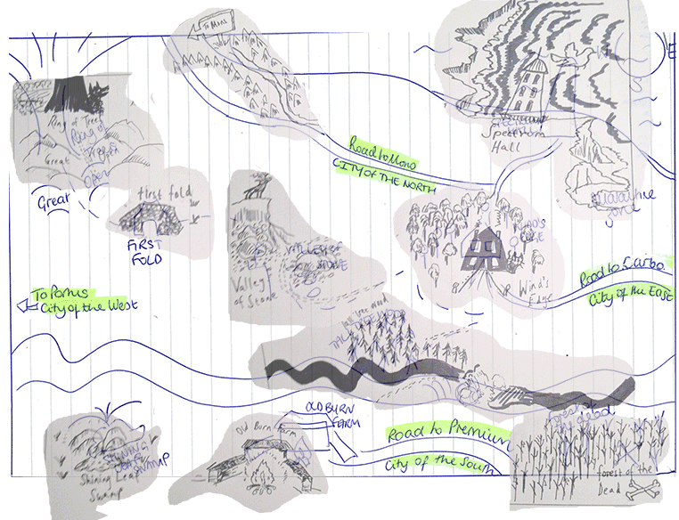
The process for drawing the maps for both the Abi Elphinstone and Piers Torday books is very similar. The process starts when I receive a hand drawn map from the author. This is a very exciting stage as it feels like I’m getting exclusive access to some secret information! When I work on a book cover or other illustrations I normally work with a designer, so it’s nice to have a direct interaction with the author.
The first stage is to start interpreting the information in the authors map into a foundation that I can start building on. I often have to shift things around to fit the page size and shape, making sure nothing too important is too close to the gutter between two pages if the map is to cover a whole double page spread. Then I start to make adjustments to the specific placing of each key feature so all the various elements feel like they flow naturally rather than artificially filling the whole space. I work digitally so it’s easy to grab different elements and shift them around, adjusting their size and placement.
While I’m making all these adjustments I also try to make sure I don’t stray to far from the authors original vision so that it properly represents their idea of the landscape. I don’t normally have access to the manuscript before working on the maps so I have to be careful not to make any changes that might contradict information in the story.

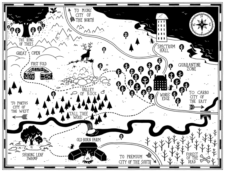
Once I’ve adjusted the basic layout the second stage is to drawing a rough sketch of how it will look. At this point I’ll start to experiment with the style of the map and how each different feature will be represented. I try to choose a style that fits the individual map while also taking account of the style of any other maps in the series. The three maps I did for Piers Torday’s ‘The Last Wild’ series all depicted slightly different environments, the first an area of countryside, the second a city and the third a large area of land and sea. I tried to give each map an individual look that matched the environment, while at the same time felt related to the other maps in the series.
I keep working on a rough until it feels right. Sometimes the result can be really sketchy, while at other times it can look fairly similar to the finished image. Ideally a rough shouldn’t be too overworked. It’s risky to spend time working on something too much before you check everything is moving in the right direction.
Once I feel the rough is ready I send it to get approval from the author and the designer. They can give feedback if any details aren’t quite right, either in how they’re depicted or where they’re placed. I always seem to manage to get a few spelling mistakes into every map rough somehow!

Once the rough is approved I can get going on the final image. I work digitally, drawing the finished image from scratch, with the rough version as a guide underneath. This stage can take quite a while but it is always very enjoyable. I tend not to be too systematic and I jump around the whole map working on which ever detail grabs my attention at that time.
If the map has any text I try to add this fairly early on so that I can make sure all the details and features fit easily around each piece of text. Its easier to do this early on before the map gets too crowded. I like to try and play around with the typography to make sure it fits with theme and style of the map. I like to think that hand-lettering any text helps the information sit more comfortably alongside the hand-drawn map.
The last stage of the final drawing tends to be adding small details around the maps key features so that the landscape has a natural feel, and that the whole image feels balanced. Once this is done I send the drawing off once again to be checked for errors and to get everyone’s input. There is often another spelling mistake to be caught! Once it gets the all clear the map is finished and ready to greet the reader when they open the book.


Is it a part of your job that you particularly enjoy?
I really enjoy working on the rough and figuring out how everything will work. It’s like a puzzle and I really enjoy puzzles! For these maps it can be a fairly long process but it’s very satisfying to see the landscape appear piece by piece. Also, because I haven’t read the story beforehand it can feel very similar to how a reader might feel upon seeing a map at the beginning of a book, I start to wonder where the characters might go and what might happen there. It’s fun to think about the potential adventures ahead as I draw.
What unmapped story would you most like to see mapped?

I’d love to see some maps in the Harry Potter books, it would be quite a challenge to draw them but it would be great to have a map of Hogwarts and places such as Diagon Alley and Hogsmeade.
Do you have any specific cartographic influences?

I’m a big fan of video games and in the 90’s it wasn’t uncommon for a big foldout map to come in the box with some big adventure games. I used to love looking at each map before starting each game imagining the adventure ahead. I can remember the map that came with a game called ‘The Secret of Mana’ being a particular favourite of mine. There are plenty of maps that would appear in the games as well, although i always liked the printed maps the most. These video game maps alongside the maps I’d find in my favourite books have probably been a big influence on how I think about the maps I draw now.

I’m also a big fan of mazes and was lucky enough to draw a load of them in my first book ‘Thomas Flintham’s Marvellous Mazes’ (now collected in ‘Thomas Flintham’s Book of Mazes and Puzzles’!). I like the idea of a maze being an adventure through an image. For a maze to work it can’t be too obvious which way to go, which is something that applies to the maps I draw as well. I like the map to suggest where the adventure might go but you don’t want to make it too signposted, so the thought process of designing maps and mazes is kind of similar.


What are your favourite maps from other books?
I’m a massive fan of Tove Jansson’s Moomin books and the maps she drew last the start of each book are as brilliant as the rest of her illustrations. Each one is beautifully drawn with lots of characters and details throughout. I think Jansson’s illustration’s are pretty much perfect and her maps are no different!


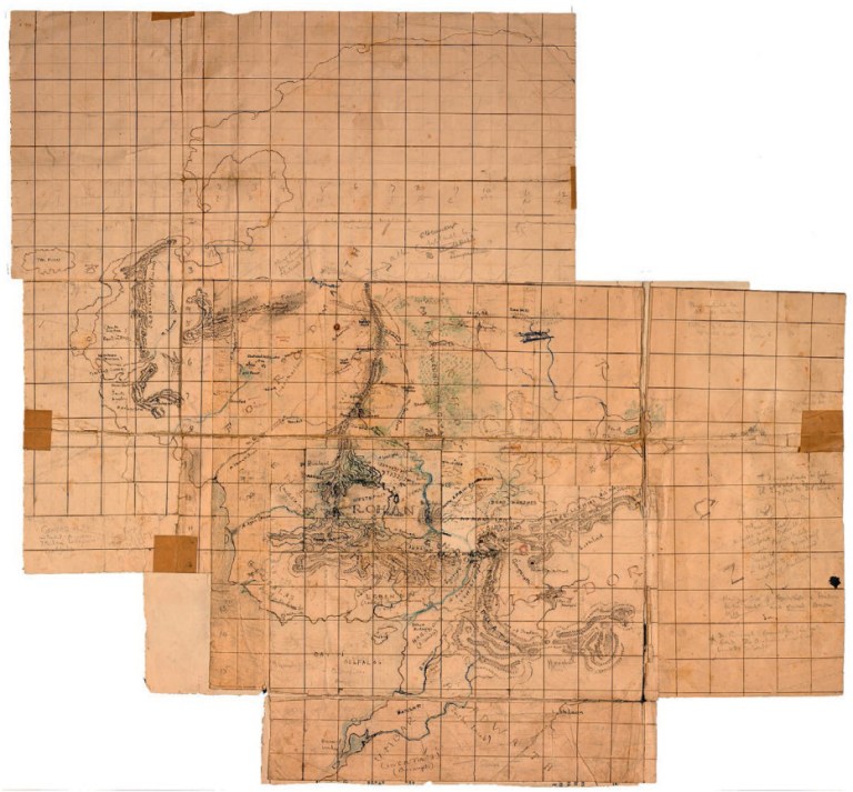
Another favourite is the map that J.R.R. Tolkien drew for ‘The Hobbit’. It’s beautifully simple in how its drawn, and you don’t doubt for a moment that it’s the same map used within the story, which really connects you to the adventures of Bilbo and the Dwarves. As you refer back to the map as they get closer to the misty mountain it really connects you to their adventure.
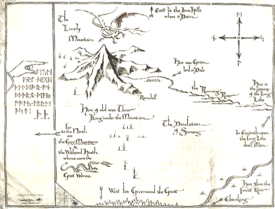
The maps he drew for the ‘Lord of the Rings’ books are definitely favourites of mine as well. They’re much more detailed than the map he drew for the Hobbit, and they really help you to make sense of the less straightforward journey of Frodo and the Fellowship. The maps really help the world of Middle Earth to feel gigantic and alive as there are so many places shown and named on the maps that don’t even appear in the story. Tolkien’s hand drawn maps are the standard I try to aspire to, they add so much extra adventure to his books.
You can see lots more maps on my Pinterest board.


This is a marvellous post about the marvellous enterprise of creating and drawing maps, and with a bit of maze-related inspiration what’s not to like? Hurrah for Thomas Flintham and his colleagues in enterprise!
Just completed (with a review due tomorrow) an account of the Great Trigonometrical Survey of India substantially completed by George Everest, complete with its vast triangulation of the sub-continent so as to produce the most accurate physical maps possible. Luckily fantasy maps — even Middle Earth — don’t have the same problems of scale!
LikeLike
Thank you for such a lovely post. I used to make maps as a child. They were total fiction and included buried treasure and a smoking volcano. The most important part for me was staining the paper with tea so it looked old and burning the edges without destroying my artwork or my mum finding out I was playing with matches.
LikeLike